
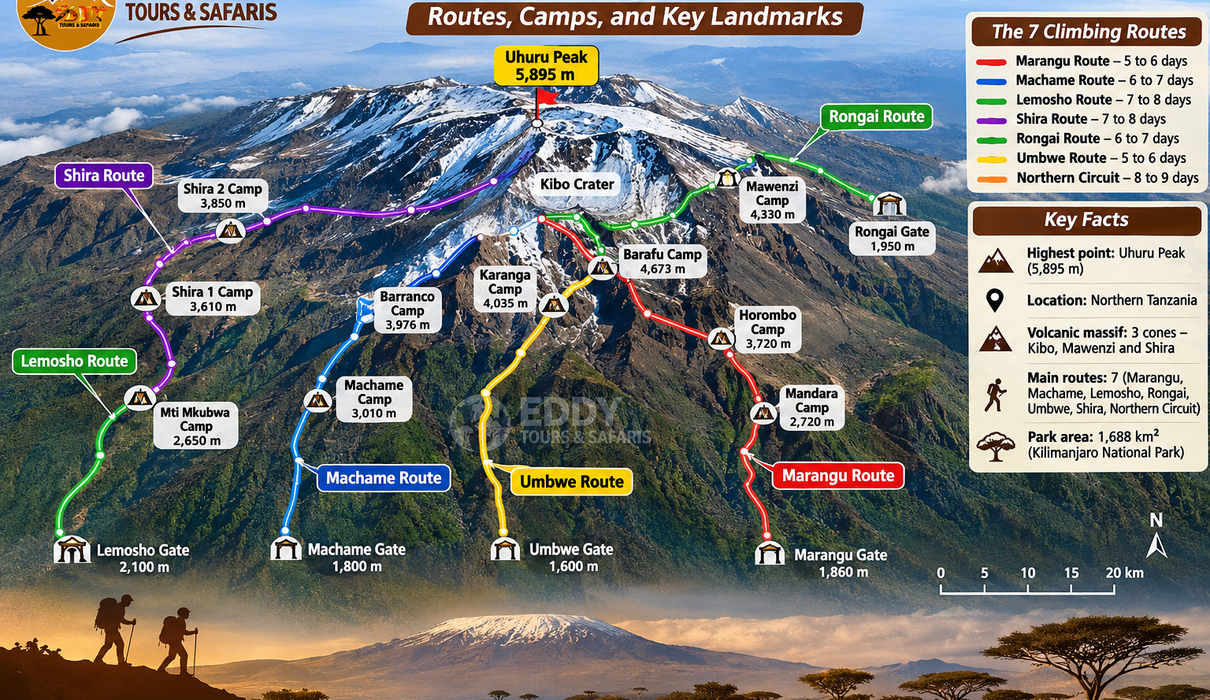
Mount Kilimanjaro is the highest mountain in Africa, rising 5,895 metres (19,341 feet) above sea level in northern Tanzania. Every year, climbers from different parts of the world travel to Tanzania to reach Uhuru Peak, the mountain’s highest point. Before choosing a climbing route, however, it is important to understand the geography of Kilimanjaro, the location of its trekking trails, the camps used along each route, and the main landmarks encountered during the ascent.
A detailed Mount Kilimanjaro map helps climbers understand how the different routes approach the summit. Some trails begin in the rainforest on the southern slopes, while others approach from the western or northern side of the mountain. Although most climbing routes eventually lead towards the summit of Kibo, they differ considerably in distance, scenery, accommodation, acclimatisation opportunities, and the number of days required.
The most widely used Kilimanjaro climbing routes include Machame, Marangu, Lemosho, Rongai, Umbwe, Shira, and the Northern Circuit. The mountain also has designated descent trails, including Mweka Route, which is used by climbers descending from several southern and western approaches. Understanding how these routes connect is useful when selecting an itinerary because two routes may begin in completely different locations but share the same camps during the final stages of the climb.
This updated guide explains the Mount Kilimanjaro climbing map in detail, including the main routes, entry gates, camping locations, mountain elevations, summit trails, and natural landmarks. It also compares the routes to help travellers choose a suitable Kilimanjaro climbing itinerary for their fitness, experience, and available time.
Where Is Mount Kilimanjaro Located?
Mount Kilimanjaro is located in northeastern Tanzania, within the Kilimanjaro Region, near the border with Kenya. The mountain lies approximately 80 kilometres east of Arusha in a straight line, although driving distances depend on the starting point and the park gate being used. Moshi is the nearest major town and serves as an important base for climbing expeditions, while Arusha is another popular starting point for travellers combining Kilimanjaro trekking with Tanzania wildlife safaris.
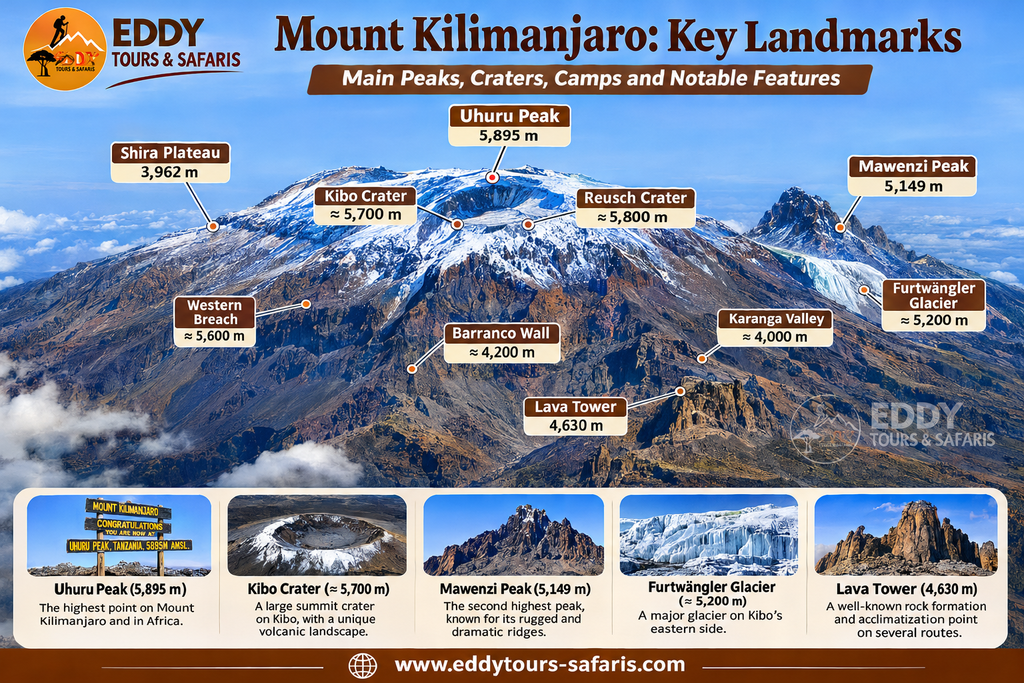
Kilimanjaro is a volcanic mountain consisting of three main volcanic formations: Kibo, Mawenzi, and Shira. Kibo is the highest and contains Uhuru Peak, while Mawenzi is known for its rugged rocky peaks. Shira is the oldest volcanic formation and is associated with the broad Shira Plateau on the western side of the mountain.
The mountain’s geography is important because the climbing routes approach these volcanic formations from different directions. Western routes generally cross the Shira Plateau, southern routes pass through rainforest and heathland before reaching Barranco, and the northern routes travel across quieter slopes before joining the summit approach.
According to the Tanzania National Parks Authority, Kilimanjaro’s principal volcanic formations are Kibo at 5,895 metres, Mawenzi at approximately 5,149 metres, and Shira at approximately 3,962 metres.
Understanding the Mount Kilimanjaro Climbing Routes Map
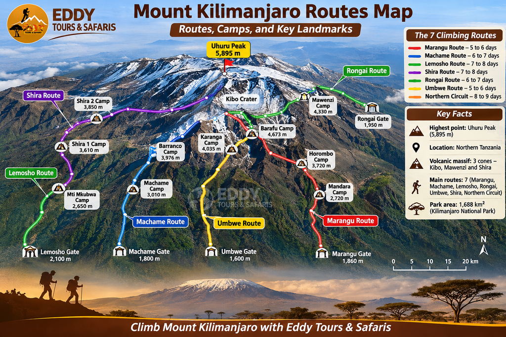
A Mount Kilimanjaro route map shows how the trekking trails extend from the lower slopes towards the mountain’s central summit area. Most maps identify the entry gates, campsites, mountain huts, summit points, connecting trails, and descent routes. Some also include altitude contours, vegetation zones, park boundaries, and nearby settlements.
When examining the map, it is useful to remember that the summit is located on Kibo, the central and highest volcanic cone. The different routes approach Kibo from several directions, and their paths often join as climbers reach the higher elevations.
The western side of Kilimanjaro contains the Lemosho and Shira approaches, which lead towards the Shira Plateau. Machame and Umbwe begin on the southern slopes, while Marangu approaches from the southeast. Rongai begins on the northern side, close to the Kenyan border, and the Northern Circuit travels around the quieter northern slopes before reaching the eastern summit approach.
The mountain map also shows an important distinction between ascent and descent routes. Climbers using Machame, Lemosho, Umbwe, and many Northern Circuit itineraries normally descend through the Mweka trail, while Marangu climbers generally return through the same southeastern corridor used during their ascent.
Mount Kilimanjaro Routes at a Glance
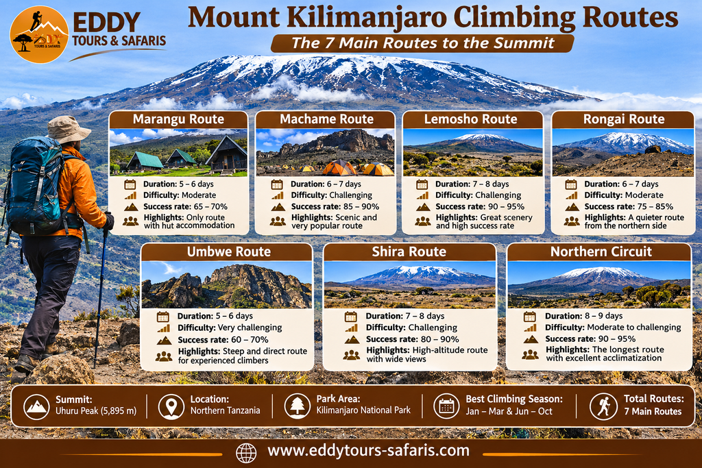
| Climbing Route | Starting Direction | Typical Duration | Main Accommodation | Common Descent |
|---|---|---|---|---|
| Machame | Southwest | 6–7 days | Tented camps | Mweka |
| Marangu | Southeast | 5–6 days | Mountain huts | Marangu |
| Lemosho | West | 7–8 days | Tented camps | Mweka |
| Rongai | North | 6–7 days | Tented camps | Marangu |
| Umbwe | South | 6–7 days | Tented camps | Mweka |
| Shira | West | 7–8 days | Tented camps | Mweka |
| Northern Circuit | West, then northern slopes | 8–9 days or longer | Tented camps | Mweka |
These durations are typical examples rather than fixed requirements. Some operators offer shorter or longer variations, and the camps used may change according to the itinerary, available facilities, and park arrangements.
For travellers comparing Kilimanjaro climbing options, Eddy Tours & Safaris’ 8-Day Lemosho Route itinerary provides an example of a western approach that crosses the Shira Plateau before joining the southern summit circuit.
1. Machame Route Map – The Southern Approach to Kilimanjaro
The Machame Route is one of the most widely used climbing routes on Mount Kilimanjaro. It begins at Machame Gate on the southwestern side of the mountain and passes through rainforest, heathland, moorland, and alpine desert before reaching the summit. The route is particularly popular because of its varied scenery and the opportunity to experience several different landscapes during the climb.
The standard Machame trail begins at approximately 1,800 metres and gradually ascends towards Machame Camp. From there, climbers continue towards Shira Camp, cross the high-altitude landscape near Lava Tower, and descend into Barranco Valley. The route then follows the southern circuit through Karanga and Barafu before the final summit attempt.
One of the main advantages of Machame is its elevation profile. Climbers often walk to a higher altitude during the day before sleeping at a lower camp, particularly on the section between Lava Tower and Barranco. This can support acclimatisation, although it does not eliminate the risk of altitude sickness.
Main Camps on the Machame Route
| Camp or Landmark | Approximate Elevation |
|---|---|
| Machame Gate | 1,800 m |
| Machame Camp | 2,835 m |
| Shira Cave Camp | 3,750 m |
| Lava Tower | 4,630 m |
| Barranco Camp | 3,900 m |
| Karanga Camp | 4,035 m |
| Barafu Camp | 4,640 m |
| Stella Point | 5,756 m |
| Uhuru Peak | 5,895 m |
| Mweka Camp | 3,100 m |
| Mweka Gate | 1,640 m |
The seven-day Machame itinerary usually includes an overnight stay at Karanga Camp, while some six-day variations continue from Barranco towards Barafu without spending a night at Karanga. The additional day can provide more time for acclimatisation and recovery before the summit attempt.
2. Marangu Route Map – The Kilimanjaro Hut Route
The Marangu Route approaches Kilimanjaro from the southeastern side and is particularly well known because it uses mountain huts rather than the tented camps found on most other routes. It is sometimes called the Coca-Cola Route, although that nickname should not be taken to mean that the climb is easy.
Marangu begins at Marangu Gate and follows a forest trail towards Mandara Hut. Climbers then continue through moorland towards Horombo Hut before crossing the alpine landscape between Kibo and Mawenzi to reach Kibo Hut. The final summit attempt generally begins during the night, with climbers ascending towards Gilman’s Point before continuing around the crater rim to Uhuru Peak.
Unlike Machame and Lemosho, the Marangu Route normally uses the same general corridor for ascent and descent. This means climbers return through Horombo and Mandara after their summit attempt.
Main Huts and Landmarks on the Marangu Route
| Hut or Landmark | Approximate Elevation |
|---|---|
| Marangu Gate | 1,860 m |
| Mandara Hut | 2,720 m |
| Horombo Hut | 3,720 m |
| Zebra Rocks | 4,000 m |
| Kibo Hut | 4,700 m |
| Gilman’s Point | 5,685 m |
| Uhuru Peak | 5,895 m |
Marangu is attractive to travellers who prefer sleeping in permanent huts rather than tents. However, the five-day version allows relatively little time for acclimatisation, and many climbers choose a six-day itinerary with an additional day at Horombo. The mountain remains physically demanding regardless of the accommodation used.
3. Lemosho Route Map – Western Kilimanjaro and the Shira Plateau
The Lemosho Route begins on the western side of Mount Kilimanjaro and is widely regarded as a good option for travellers who want a longer trek with varied scenery. The route approaches through forest before reaching the Shira Plateau, where climbers experience open landscapes and views towards Kibo.
A typical Lemosho itinerary begins with registration at Londorossi Gate, followed by transport towards the Lemosho trailhead. Climbers walk through forest to Mti Mkubwa Camp before continuing towards Shira 1 and Shira 2. From the Shira Plateau, the route generally continues towards Lava Tower and Barranco, where it joins the southern circuit used by Machame climbers.
Longer Lemosho itineraries allow additional time at intermediate elevations, which can help climbers adjust to altitude before reaching the summit. The eight-day variation is a popular choice for people who want more acclimatisation time without taking an exceptionally long route around the mountain.
Main Camps on the Lemosho Route
| Camp or Landmark | Approximate Elevation |
|---|---|
| Londorossi Gate | 2,250 m |
| Lemosho Trailhead | 2,100 m |
| Mti Mkubwa Camp | 2,650 m |
| Shira 1 Camp | 3,500 m |
| Shira 2 Camp | 3,850 m |
| Lava Tower | 4,630 m |
| Barranco Camp | 3,900 m |
| Karanga Camp | 4,035 m |
| Barafu Camp | 4,640 m |
| Uhuru Peak | 5,895 m |
| Mweka Camp | 3,100 m |
Some Lemosho variations use Moir Hut or other designated camps rather than following exactly the same overnight sequence. For this reason, travellers should compare the specific itinerary with the route map before booking.
You can review an example through Eddy Tours & Safaris’ 7-Day Kilimanjaro Lemosho Climb or compare it with the 8-Day Lemosho itinerary.
4. Rongai Route Map – The Northern Approach Near Kenya
The Rongai Route approaches Mount Kilimanjaro from the northern side, close to the border between Tanzania and Kenya. It differs from the southern and western routes because it travels through a generally drier side of the mountain and offers views of landscapes that many climbers on the other trails do not see.
The route normally begins at Rongai Gate and continues through forest and moorland towards Simba Camp. Depending on the itinerary, climbers may pass Second Cave, Third Cave, Kikelewa Camp, and Mawenzi Tarn before continuing towards Kibo Hut.
The landscape around Mawenzi Tarn is particularly interesting because it lies beneath the rugged peaks of Mawenzi. From this area, climbers cross the broad alpine saddle between Mawenzi and Kibo before reaching Kibo Hut for the final summit attempt.
Rongai climbers generally descend through the Marangu Route, creating an opportunity to experience different sides of the mountain during the ascent and descent.
Main Camps on the Rongai Route
| Camp or Landmark | Approximate Elevation |
|---|---|
| Rongai Gate | 1,950 m |
| Simba Camp | 2,625 m |
| Second Cave | 3,450 m |
| Kikelewa Camp | 3,600 m |
| Mawenzi Tarn Camp | 4,330 m |
| Kibo Hut | 4,700 m |
| Gilman’s Point | 5,685 m |
| Uhuru Peak | 5,895 m |
| Horombo Hut | 3,720 m |
| Marangu Gate | 1,860 m |
Rongai can be a suitable option for travellers interested in a northern approach, but the route still involves demanding high-altitude trekking. A longer itinerary with adequate acclimatisation time is generally preferable to rushing towards the summit.
5. Umbwe Route Map – A Steep Southern Kilimanjaro Trail
The Umbwe Route begins on the southern slopes of Kilimanjaro and is known for its steep ascent through rainforest and narrow ridges. It is generally considered one of the more demanding approaches because climbers gain altitude quickly during the early stages.
The trail begins at Umbwe Gate and climbs towards Umbwe Cave Camp before continuing to Barranco Camp. From Barranco, the route joins the southern circuit and follows the same general approach towards Karanga, Barafu, and Uhuru Peak.
Because Umbwe gains elevation rapidly, it provides fewer gradual acclimatisation opportunities during the initial stages than longer routes such as Lemosho or the Northern Circuit. It is therefore better suited to experienced trekkers who understand the demands of high-altitude hiking and have selected an appropriate itinerary.
Main Camps on the Umbwe Route
| Camp or Landmark | Approximate Elevation |
|---|---|
| Umbwe Gate | 1,600 m |
| Umbwe Cave Camp | 2,850 m |
| Barranco Camp | 3,900 m |
| Karanga Camp | 4,035 m |
| Barafu Camp | 4,640 m |
| Uhuru Peak | 5,895 m |
| Mweka Camp | 3,100 m |
Umbwe is not automatically a better route simply because it is more difficult. Climbers should consider their fitness, previous altitude experience, and the number of days available before choosing this approach.
6. Shira Route Map – Starting High on the Western Plateau
The Shira Route approaches Kilimanjaro from the western side and shares several sections with Lemosho. The main difference is that Shira itineraries often begin at a relatively high elevation after travelling by vehicle towards the Shira Plateau.
This can reduce the amount of lower-altitude trekking, but it also means climbers may reach significant altitude quickly. People arriving from low elevations should consider the possible effects of this rapid change, particularly if they have not spent time acclimatising beforehand.
The Shira Route typically crosses the western plateau before continuing towards Lava Tower and joining the southern circuit. Depending on the itinerary, climbers may use Shira 2, Moir Hut, Barranco, Karanga, and Barafu camps.
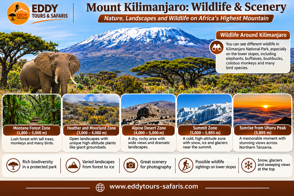
The Shira Plateau is one of Kilimanjaro’s most important geographical landmarks because it represents the remains of the mountain’s older volcanic structure. The area is known for its open moorland, distinctive vegetation, and views towards Kibo.
7. Northern Circuit Route Map – The Longest Common Kilimanjaro Trek
The Northern Circuit is one of the longest commonly offered Kilimanjaro climbing itineraries. It usually begins from the western side of the mountain, following the early stages of Lemosho before turning towards the quieter northern slopes.
Rather than continuing directly towards Barranco, Northern Circuit climbers travel around the northern side of Kibo through remote high-altitude landscapes. The route may pass Moir Hut, Buffalo Camp, Third Cave, and School Hut before the summit attempt.
The main advantage of this route is the additional time available for acclimatisation. Climbers also experience a wider range of mountain scenery, including areas that are less frequently visited than the southern circuit.
Main Camps on the Northern Circuit
| Camp or Landmark | Approximate Elevation |
|---|---|
| Lemosho Trailhead | 2,100 m |
| Mti Mkubwa Camp | 2,650 m |
| Shira 1 Camp | 3,500 m |
| Shira 2 Camp | 3,850 m |
| Moir Hut | 4,200 m |
| Buffalo Camp | 4,020 m |
| Third Cave | 3,870 m |
| School Hut | 4,750 m |
| Uhuru Peak | 5,895 m |
| Mweka Camp | 3,100 m |
Northern Circuit itineraries commonly take eight or nine days, although some variations are longer. The route is suitable for travellers who have enough time and want a gradual approach to the summit, but altitude illness remains possible even on extended itineraries.
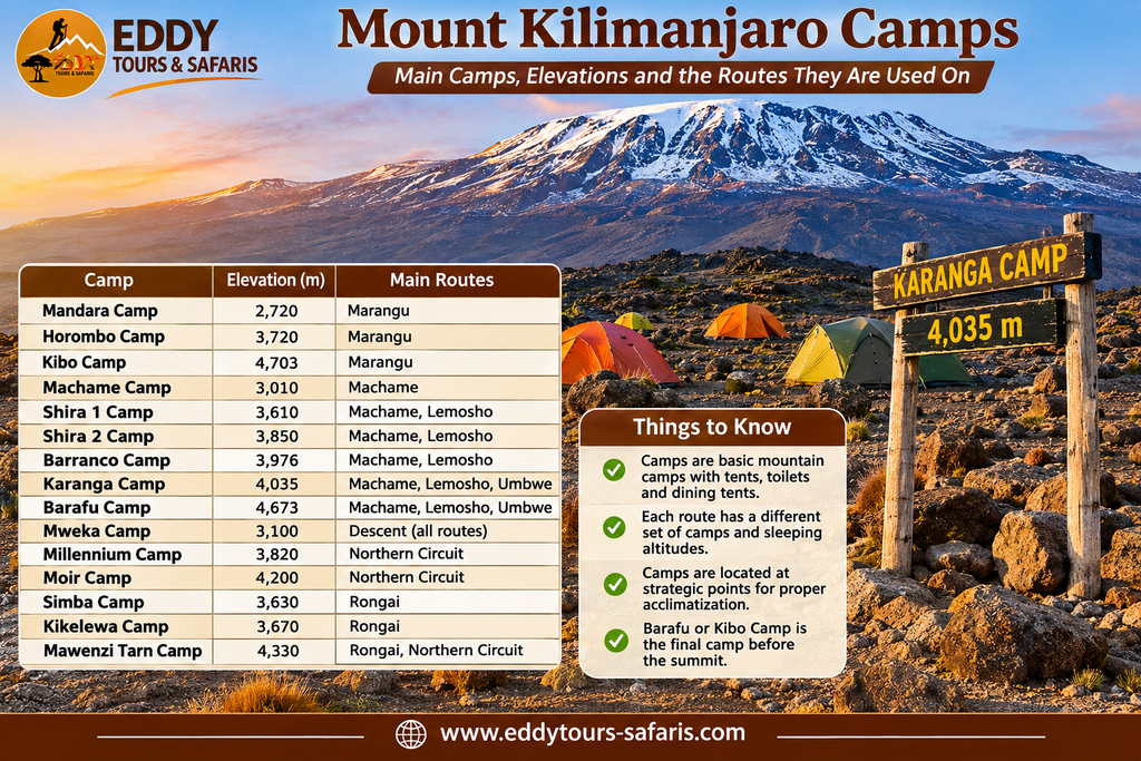
Mount Kilimanjaro Camps and Their Elevations
One of the most useful features of a detailed Kilimanjaro map is the location of the mountain camps. These camps are important because they determine the daily hiking distance, elevation gain, and sleeping altitude during the expedition.
Climbers should understand that reaching a higher camp is not simply a matter of covering more kilometres. Walking at 4,000 metres can be considerably more demanding than walking the same distance at lower elevations because the reduced availability of oxygen affects physical performance.
The following table summarises important camps used across the main Kilimanjaro routes.
| Camp or Hut | Approximate Elevation | Main Route Association |
|---|---|---|
| Mandara Hut | 2,720 m | Marangu |
| Horombo Hut | 3,720 m | Marangu, Rongai descent |
| Kibo Hut | 4,700 m | Marangu, Rongai |
| Machame Camp | 2,835 m | Machame |
| Shira Cave Camp | 3,750 m | Machame |
| Mti Mkubwa Camp | 2,650 m | Lemosho, Northern Circuit |
| Shira 1 Camp | 3,500 m | Lemosho, Northern Circuit |
| Shira 2 Camp | 3,850 m | Lemosho, Shira, Northern Circuit |
| Moir Hut | 4,200 m | Northern Circuit and selected western itineraries |
| Barranco Camp | 3,900 m | Machame, Lemosho, Umbwe |
| Karanga Camp | 4,035 m | Southern Circuit |
| Barafu Camp | 4,640 m | Southern Circuit summit approach |
| Simba Camp | 2,625 m | Rongai |
| Kikelewa Camp | 3,600 m | Rongai |
| Mawenzi Tarn Camp | 4,330 m | Rongai |
| Buffalo Camp | 4,020 m | Northern Circuit |
| Third Cave | 3,870 m | Northern Circuit and Rongai variations |
| School Hut | 4,750 m | Northern Circuit and selected summit itineraries |
| Mweka Camp | 3,100 m | Descent from several routes |
These elevations should be used as planning references rather than precise navigation coordinates. Before travelling, confirm the camps and elevations shown on your operator’s itinerary and the current official park map.
Important Landmarks on the Mount Kilimanjaro Map
Kilimanjaro contains several natural landmarks that help climbers understand the mountain’s geography. Some are important because they mark changes in elevation or terrain, while others are known for their geological features, scenery, or role in the summit approach.
Uhuru Peak – 5,895 Metres
Uhuru Peak is the highest point on Mount Kilimanjaro and the main destination for summit climbers. It is located on the crater rim of Kibo and stands 5,895 metres above sea level. Reaching the summit involves trekking through high-altitude terrain where temperatures can be extremely cold and the reduced availability of oxygen makes physical activity more demanding.
Most summit attempts begin during the night or very early morning. Climbers using Barafu generally approach through Stella Point, while those ascending from Kibo Hut commonly reach Gilman’s Point before continuing along the crater rim. The final section to Uhuru Peak may be physically exhausting, even for climbers who have completed the earlier stages comfortably.
Stella Point – Approximately 5,756 Metres
Stella Point is an important landmark on the southeastern crater rim of Kibo. It is commonly reached by climbers ascending from Barafu Camp on routes such as Machame, Lemosho, and Umbwe. From Stella Point, the trail continues along the crater rim towards Uhuru Peak.
Although Stella Point is close to the summit in elevation, the remaining distance can still be demanding because climbers are already operating at very high altitude. Cold temperatures, wind, fatigue, and altitude symptoms may affect progress during this final section.
Gilman’s Point – Approximately 5,685 Metres
Gilman’s Point is another important summit landmark, particularly for climbers using the Marangu and Rongai routes. It lies on the eastern side of Kibo’s crater rim and is usually reached after a steep ascent from Kibo Hut.
From Gilman’s Point, climbers continue along the crater rim towards Stella Point and Uhuru Peak. The route provides views across the summit area when weather conditions permit, but the remaining walk should not be underestimated.
Lava Tower – Approximately 4,630 Metres
Lava Tower is a prominent volcanic rock formation located on the western and southern trekking circuit. It is an important landmark for climbers using Machame, Lemosho, and selected Shira itineraries.
Many climbers visit Lava Tower during the day before descending to a lower sleeping altitude at Barranco Camp. This section is commonly associated with the principle of climbing higher during the day and sleeping lower at night, although the altitude gain can still produce symptoms in susceptible climbers.
Barranco Wall – The Famous Scrambling Section
Barranco Wall is one of Kilimanjaro’s best-known trail features. It is located above Barranco Camp and forms part of the southern circuit towards Karanga. The route involves steep walking and sections where climbers use their hands for balance while moving over rock.
The wall is sometimes called the Breakfast Wall because climbers commonly begin ascending it after breakfast. Despite its intimidating appearance from below, the standard route is generally a scrambling section rather than a technical rock climb. However, it requires care, concentration, and the ability to follow guide instructions.
Shira Plateau – Western Kilimanjaro
The Shira Plateau lies on the western side of Kilimanjaro and forms part of the ancient Shira volcanic structure. It is crossed by climbers using Lemosho, Shira, and Northern Circuit itineraries.
The plateau contains open moorland and distinctive high-altitude vegetation, with views towards Kibo in suitable weather. It also provides a geographical connection between the western climbing approaches and the higher mountain trails.
Mawenzi Peak – Approximately 5,149 Metres
Mawenzi is the second-highest volcanic formation on Mount Kilimanjaro. Unlike the broader summit of Kibo, Mawenzi has rugged ridges and steep rocky formations that create a distinctive appearance.
Climbers using the Rongai Route often enjoy views of Mawenzi from Mawenzi Tarn Camp and the surrounding trails. The mountain’s steep technical terrain is separate from the standard trekking route to Uhuru Peak, and climbing its more demanding sections requires specialised arrangements and appropriate authorisation.
Kibo–Mawenzi Saddle
The saddle is the broad, high-altitude landscape between Kibo and Mawenzi. It is particularly important for climbers travelling from Horombo towards Kibo Hut on the Marangu Route and for some northern approaches.
The terrain is exposed, with limited vegetation and long views across the alpine desert. Because climbers are already at significant altitude, walking across the saddle can feel more difficult than its relatively open appearance suggests.
For official descriptions of Kilimanjaro’s summit, volcanic formations, glaciers, and mountain landscapes, consult TANAPA’s Kilimanjaro Attractions Guide.
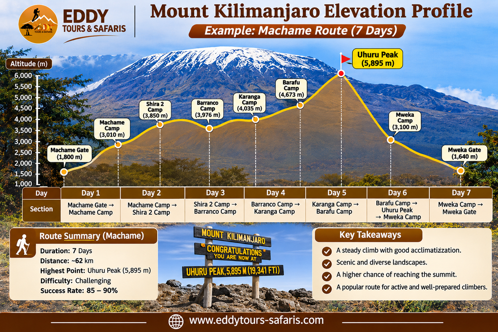
Mount Kilimanjaro Vegetation Zones Explained
Another important feature of the Kilimanjaro map is the change in vegetation and climate as elevation increases. Climbers move through several ecological zones, each with different temperatures, landscapes, and environmental conditions.
Cultivated Lower Slopes
The lower slopes of Kilimanjaro contain settlements, farms, and areas of cultivated land. Coffee, bananas, and other crops are grown in parts of the surrounding region, particularly where rainfall and soil conditions support agriculture. Most summit expeditions begin above these settled areas at designated national park gates.
Rainforest Zone
The rainforest occupies a substantial portion of Kilimanjaro’s lower mountain slopes. Climbers using Machame, Marangu, Lemosho, and Umbwe pass through forest during the early stages of their ascent. The vegetation includes tall trees, ferns, mosses, and other plants adapted to relatively moist conditions.
The rainforest may also support wildlife such as blue monkeys, colobus monkeys, and various bird species. Rainfall and muddy trails are possible, particularly during wetter periods.
Heath and Moorland Zone
As climbers move above the rainforest, the vegetation becomes shorter and more open. Heathland and moorland areas contain shrubs, grasses, giant groundsels, and other plants adapted to cooler temperatures and stronger sunlight.
This zone is particularly visible around the Shira Plateau, Horombo, and several intermediate camps. The more open landscape also provides extensive views across the mountain when clouds are absent.
Alpine Desert Zone
At higher elevations, vegetation becomes sparse and the landscape is dominated by rock, gravel, volcanic material, and exposed terrain. Temperatures can change considerably between day and night, while strong winds and intense sunlight may create challenging conditions.
Many of Kilimanjaro’s higher camps, including Barafu and Kibo Hut, are located in or near this zone. Climbers should be prepared for cold temperatures and reduced physical performance at altitude.
Arctic Summit Zone
The highest parts of Kilimanjaro are characterised by extreme cold, exposed volcanic terrain, and remaining glaciers and icefields. The summit environment is very different from the rainforest found lower on the mountain, despite the relatively short horizontal distance between them.
Snow and ice conditions vary, and climbers should not assume that the summit will always be covered by continuous snow. Proper cold-weather clothing remains essential because temperatures and wind chill can be severe.
Which Kilimanjaro Route Is Best for Beginners?
Choosing a Kilimanjaro route should involve more than comparing distances or selecting the shortest itinerary. A beginner with good general fitness may be able to complete a suitable Kilimanjaro trek, but previous hiking experience, altitude tolerance, available time, and the quality of the itinerary all matter.
For many first-time climbers, a seven-day Machame itinerary or an eight-day Lemosho itinerary can provide a reasonable balance between trekking time and acclimatisation opportunities. The Northern Circuit may also appeal to travellers who have more time and prefer a longer approach.
Marangu is sometimes advertised as the easiest route because of its hut accommodation and relatively straightforward trail layout. However, the shorter five-day version can be demanding because it provides limited time to adjust to altitude. The availability of huts does not make the high-altitude conditions easier.
Umbwe is generally less suitable for beginners because of its steep early ascent. Shira can also present acclimatisation challenges when climbers begin at a high elevation without sufficient preparation.
The most appropriate route is therefore the one that provides a realistic daily walking schedule, sufficient acclimatisation time, and support from experienced mountain guides.
How to Read Kilimanjaro Altitude Profiles
A route map shows the direction of travel, but an altitude profile explains how much elevation climbers gain and lose during each day. Both are important because a route that appears short on a map may involve substantial climbing.
For example, a trekking day from Shira Camp towards Lava Tower may involve ascending above 4,500 metres before descending to Barranco Camp at a lower elevation. Although the final sleeping altitude may be only slightly higher than the previous night, the body has experienced a much greater altitude during the day.
Similarly, summit day is usually the most demanding part of the expedition because climbers ascend from a high camp to Uhuru Peak before descending several thousand metres. This can involve many hours of walking, often with limited sleep and challenging temperatures.
When comparing Kilimanjaro itineraries, pay attention to the starting elevation, highest elevation reached during the day, sleeping altitude, walking distance, and estimated hiking hours. These details provide a more useful picture of the trek than the route name alone.
How Many Days Does It Take to Climb Mount Kilimanjaro?
Most standard Kilimanjaro climbing itineraries take between five and nine days, although longer arrangements are possible. The total duration depends on the route, number of acclimatisation days, and chosen summit approach.
A five-day Marangu itinerary is among the shorter options, while six- and seven-day Machame itineraries are common among travellers who want a southern approach. Lemosho is frequently completed in seven or eight days, while the Northern Circuit generally requires eight or nine days or longer.
Longer itineraries often provide additional opportunities for acclimatisation, but they do not guarantee summit success. Individual responses to altitude vary, and climbers should be prepared to descend if they develop concerning symptoms.
Kilimanjaro Summit Day: Understanding the Final Climb
Summit day is the most physically demanding part of most Kilimanjaro itineraries. Climbers generally begin from Barafu Camp, Kibo Hut, or another authorised high camp and ascend towards the crater rim before continuing to Uhuru Peak.
Those approaching from Barafu normally climb towards Stella Point, while climbers from Kibo Hut usually reach Gilman’s Point first. The two approaches then follow the crater rim towards Uhuru Peak, although the exact trail and conditions may vary.
The ascent often begins at night because guides aim to reach the higher mountain during the early morning hours. However, departure times depend on the route, weather, group condition, and guiding arrangements.
After reaching the summit, climbers descend towards a lower camp. On the southern circuit, this commonly means returning through Barafu and continuing towards Mweka Camp. On Marangu, climbers normally descend towards Horombo Hut.
Because summit day involves considerable physical effort, climbers should follow their guide’s pace, communicate any symptoms promptly, and avoid treating the summit as more important than their health.
Kilimanjaro Climbing Safety and Altitude Sickness
Altitude sickness is one of the main health risks associated with climbing Mount Kilimanjaro. As elevation increases, the atmospheric pressure decreases, reducing the amount of oxygen available with each breath. This can affect climbers regardless of age, general fitness, or previous hiking experience.
Symptoms of acute mountain sickness may include headache, nausea, dizziness, fatigue, and difficulty sleeping. More serious altitude illnesses can affect the lungs or brain and require urgent descent and medical attention.
Choosing a longer route can support acclimatisation, but no itinerary eliminates altitude-related risks. Climbers should follow their guides’ instructions, ascend gradually, report symptoms honestly, and avoid continuing higher when concerning symptoms develop.
Tanzania National Parks Authority requires Kilimanjaro climbs to be guided by licensed operators. Its official Kilimanjaro visitor guide also advises climbers to follow marked trails, carry suitable equipment, and prepare for changing mountain conditions.
Best Time to Climb Mount Kilimanjaro
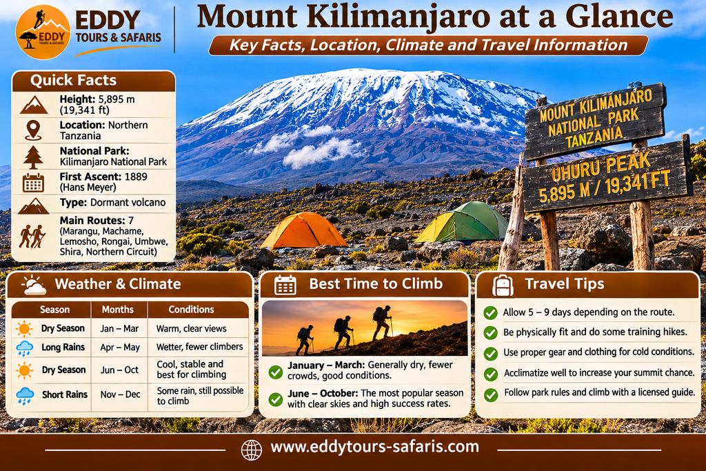
Mount Kilimanjaro can be climbed throughout the year, but weather conditions vary considerably between seasons. The relatively dry periods are generally more popular because trails may be less muddy and visibility can be better, although rain, snow, and strong winds remain possible at any time.
January to early March is often a favourable period for climbing, with relatively good conditions on many days. June to October is another popular climbing period, particularly among travellers combining Kilimanjaro with a Tanzania wildlife safari.
April and May are commonly associated with heavier rainfall, while November can bring shorter rainy periods. However, seasonal patterns are not perfectly predictable, and mountain weather can change quickly.
Kilimanjaro Climbing Seasons
| Period | General Conditions | Planning Considerations |
|---|---|---|
| January–March | Often relatively dry, with variable summit conditions | Popular climbing period |
| April–May | Typically wetter | Muddy trails and reduced visibility are possible |
| June–October | Generally drier and often cooler | Popular for trekking and safari combinations |
| November–December | Variable rainfall | Flexible preparation is important |
Climbers should select travel dates according to their available time, preferred conditions, and the itinerary that best supports acclimatisation.
Mount Kilimanjaro Map: Entry Gates and Descent Gates
Understanding the location of Kilimanjaro’s entry gates is important because different routes begin at different sides of the mountain. The driving time from Moshi or Arusha can therefore vary significantly depending on the route selected.
Machame Gate
Machame Gate is located on the southwestern side of the mountain and serves as the starting point for the Machame Route. Climbers register at the gate before beginning their trek through rainforest towards Machame Camp.
Marangu Gate
Marangu Gate is located on the southeastern slopes and is the main entrance for the Marangu Route. It is also commonly used as the exit point for climbers descending through the Marangu corridor.
Londorossi Gate
Londorossi Gate is associated with the western approaches, particularly Lemosho and Shira. Climbers commonly complete registration before continuing towards their designated trailhead.
Rongai Gate
Rongai Gate serves climbers approaching from the northern side of Kilimanjaro. It is located near the Kenyan border and is used for the Rongai Route.
Umbwe Gate
Umbwe Gate is the starting point for the steep Umbwe Route on the southern side of Kilimanjaro. The trail climbs through forest before continuing towards higher camps.
Mweka Gate
Mweka Gate is an important exit point for climbers descending from several routes that use the southern summit circuit. It is particularly associated with Machame, Lemosho, Umbwe, and many Northern Circuit itineraries.
The official TANAPA Kilimanjaro National Park map identifies these gates and the main climbing trails connecting them to the higher mountain.
Frequently Asked Questions About the Mount Kilimanjaro Map
How Many Climbing Routes Are There on Mount Kilimanjaro?
Kilimanjaro has several established climbing approaches, commonly described as Machame, Marangu, Lemosho, Rongai, Umbwe, Shira, and the Northern Circuit. Some route names describe distinct entry trails, while others refer to longer itineraries that combine established trail sections.
Which Kilimanjaro Route Has the Best Scenery?
Lemosho, Machame, and the Northern Circuit are popular among travellers interested in varied landscapes. Lemosho crosses the Shira Plateau, Machame includes the southern circuit and Barranco Wall, and the Northern Circuit travels around quieter northern slopes.
Which Route Is Best for Acclimatisation?
Longer itineraries generally provide more time for acclimatisation. Eight-day Lemosho and nine-day Northern Circuit climbs are commonly considered suitable options for travellers who want additional days on the mountain, although altitude sickness remains possible.
What Is the Highest Camp on Kilimanjaro?
School Hut and other authorised high camps are among the highest commonly used sleeping locations, at approximately 4,750 metres. Kibo Hut and Barafu Camp are also important high-altitude camps used before summit attempts.
Is Uhuru Peak the Same as Kibo Peak?
Uhuru Peak is the highest point on the rim of Kibo, Kilimanjaro’s tallest volcanic cone. It stands at 5,895 metres above sea level and is the main summit destination for trekkers.
Can You Climb Kilimanjaro Without a Guide?
No. Kilimanjaro National Park requires climbers to use authorised guiding arrangements. Independent unguided summit trekking is not permitted under the park’s visitor regulations.
Which Kilimanjaro Route Uses Mountain Huts?
The Marangu Route is the main standard trekking route using permanent mountain huts, including Mandara, Horombo, and Kibo. Most other routes use designated campsites and tents.
Where Is Barranco Wall Located?
Barranco Wall is located on the southern circuit above Barranco Camp. It is encountered by climbers using routes such as Machame, Lemosho, and Umbwe before continuing towards Karanga.
How Far Is Kilimanjaro from Arusha?
Mount Kilimanjaro is approximately 80 kilometres east of Arusha in a straight line, but the actual driving distance to a climbing gate is longer and depends on the route selected. Many expeditions begin with a road transfer from Arusha or Moshi.
Can You Combine Kilimanjaro Climbing with a Tanzania Safari?
Yes. Many travellers climb Kilimanjaro before visiting Tarangire, Ngorongoro Crater, or Serengeti National Park. Arusha is a convenient base for organising both mountain trekking and northern Tanzania wildlife safaris.
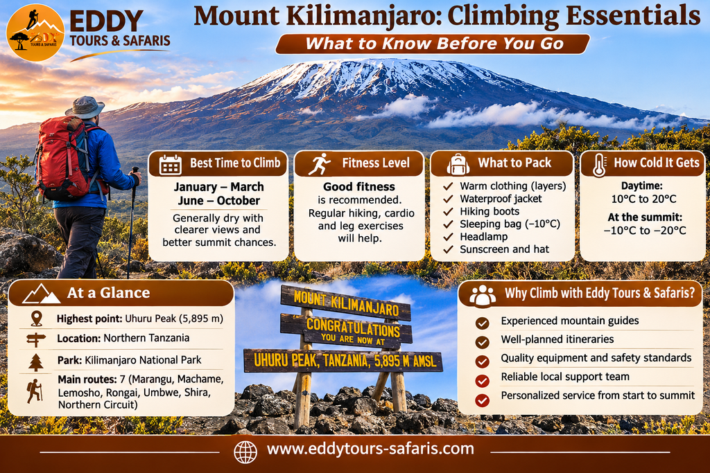
Plan Your Mount Kilimanjaro Climb with Eddy Tours & Safaris
Choosing the right Kilimanjaro route begins with understanding the mountain map, the location of its camps, and the differences between the available trekking itineraries. Although all standard summit routes lead towards Uhuru Peak, the experience varies considerably depending on where the climb begins, how quickly altitude is gained, and how much time is available for acclimatisation.
Machame is popular for its varied scenery and southern circuit, while Marangu provides hut accommodation and a more direct southeastern approach. Lemosho offers a longer western route across the Shira Plateau, Rongai approaches from the north, and the Northern Circuit provides an extended trek around the mountain. Umbwe is a steeper alternative that requires careful consideration, particularly for climbers with limited altitude experience.
Eddy Tours & Safaris is a local tour company in Arusha, Tanzania, arranging guided Mount Kilimanjaro climbing expeditions, Tanzania wildlife safaris, and private holidays. Our team can help you compare climbing routes, select a suitable number of trekking days, and understand the camps and landmarks included in your itinerary.
If you are planning to climb Mount Kilimanjaro, explore our 7-Day Lemosho Route itinerary and 8-Day Lemosho Route itinerary, or contact us for assistance with other climbing routes.
Contact Eddy Tours & Safaris
Location: Arusha, Tanzania
Email: sales@eddytours-safaris.com
Phone/WhatsApp: +255 711 906 664
Website: Eddy Tours & Safaris
Climbing enquiries: Contact Eddy Tours & Safaris